When Existing Conditions Data Fails You, Construction Pays the Price
Renovation and upgrade projects are only as reliable as the information behind them. When that information is incomplete, the resulting issues tend to show up during construction when the cost for rework and change is at its highest. Outdated drawings, missed dimensions, and hard-to-reach spaces have long been the source of costly surprises that compress budgets and push timelines.
At SMRT, we employ LiDAR technology to address that problem directly. It is now standard practice for how we approach any project involving an existing building. Here’s how it works, why traditional documentation methods fall short, and what more accurate existing conditions data means for your project from design through construction.
How SMRT Uses LiDAR
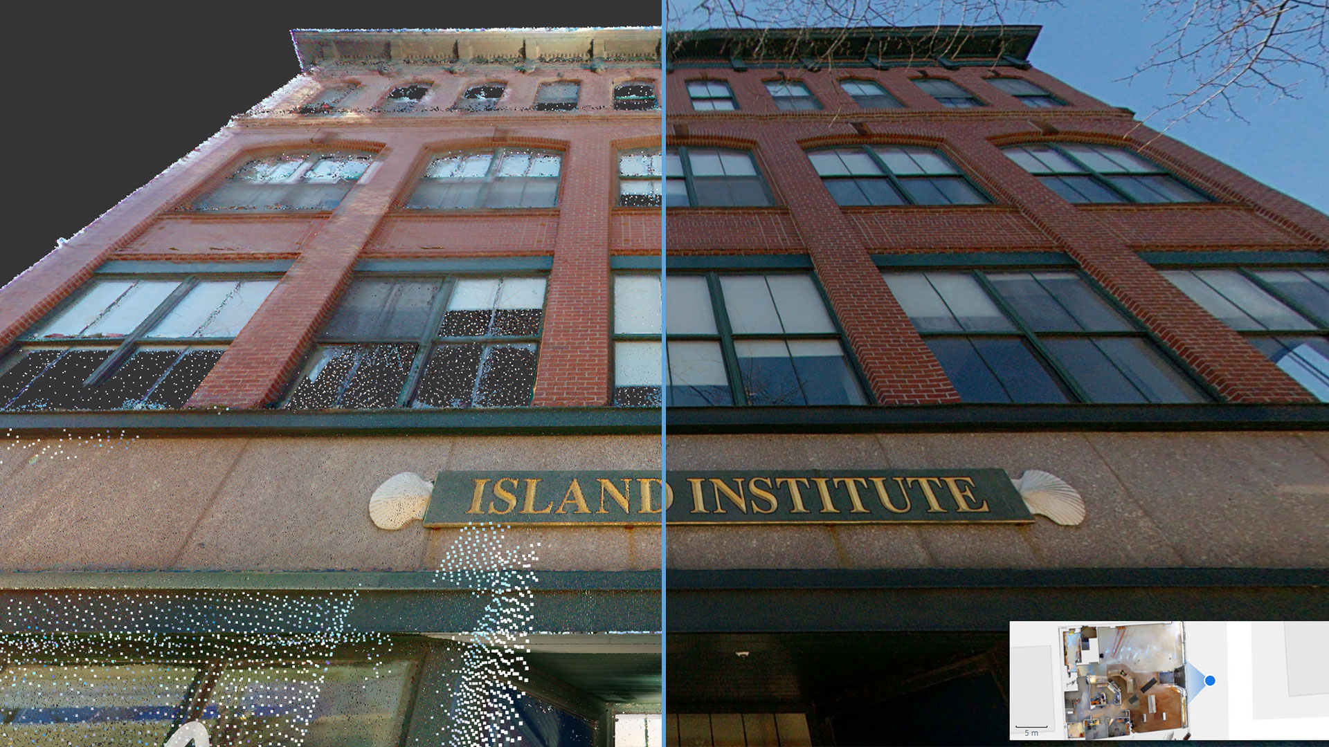
LiDAR (Light Detection and Ranging) captures existing building information in precise, measurable 3D detail. While newer to the AEC industry, this same technology has long been used for mapping and measurement purposes for years: think Google Street View, deployed inside and around your building.
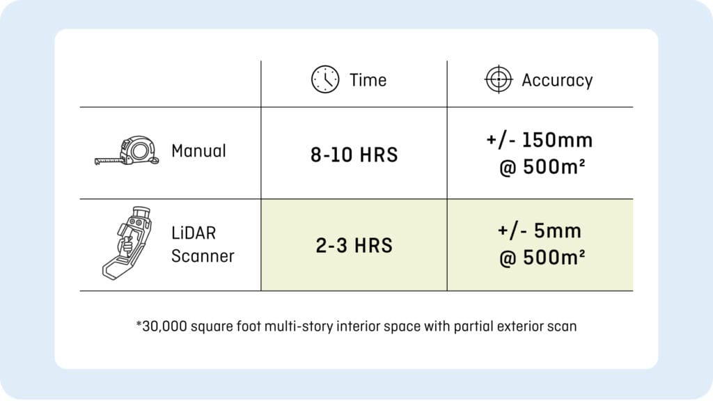
In a single site visit, SMRT uses LiDAR scanners to simultaneously capture panoramic photography and 3D measurement data for any visible building element. A 30,000 square foot facility can be fully captured in just a few hours, consistently outperforming manual documentation methods by a significant margin across our project experience. The result is a rich, accurate 3D “snapshot” of your building as it exists today.
The Problem with Traditional Documentation Methods
Tape measures, hand lasers, and photographs have been the industry standard for decades. They get the job done, but they come with limitations that create critical issues downstream.
Manually documenting a large facility is time-intensive, often requiring a full day or more on site with multiple team members. More importantly, gaps in information are all but inevitable regardless of the effort.
Those gaps may not surface until construction is underway, at which point resolving them means change orders, schedule delays, and cost exposure that could have been avoided earlier in the process.
Scanning Benefits and Outcomes
Because LiDAR captures your entire facility in 3D, the data is comprehensive and reliable. Every visible surface, component, and detail is recorded accurately within a few millimeters of reality.
The data can be accessed, measured, and investigated remotely by anyone on the project team: clients, contractors, or SMRT’s design teams, without the need for additional site visits. Scan data is delivered through an online platform that allows the team to virtually walk through the space, take measurements, and examine details from their desk. If questions come up during design, the answer is a few clicks away. Even interstitial spaces that are difficult to document traditionally can be partially captured by positioning these portable scanners above drop ceilings or in otherwise hard-to-reach areas.
The downstream effects are significant. Fewer gaps in existing conditions mean fewer assumptions during design and fewer surprises during construction. Change orders get reduced, timelines stay on track, and the project team can focus on delivering results rather than chasing missing information.
Investing in Better Data
The cost of construction continues to rise, and the margin for error continues to shrink. Catching incomplete or inaccurate existing conditions information early in design is one of the most reliable ways to protect schedule, budget, and scope. LiDAR scanning makes that possible. By capturing a facility in substantial, measurable 3D detail in a fraction of the time required by traditional methods, we build a stronger foundation for design from day one.
As the technology continues to advance, becoming faster, more portable, and more accessible, its value to renovation projects will only grow. For owners and facilities teams, the decision to scan early is one of the lowest-cost, highest-return investments in the design process. Better data at the start means better outcomes at the end.